
Halloween for this year is looking chilly and dry. That’s a lot better than what occurred just 30 years ago on the same night. 2021 marks the 30th anniversary of the famous Halloween Blizzard here in Minnesota.
Halloween Blizzard Recap from the Minnesota DNR
By mid-morning on Halloween, the snow had started to be spreading over portions of southern and southeastern Minnesota. Hourly statements issued by the National Weather Service throughout the day indicated that a large expanding mass of precipitation was taking over the southern 2/3 of Minnesota. The snowfall reached the Twin Cities area before noon and never let up in a noticeable fashion for about 24 hours. It’s also important to mention that the snow did not stop altogether for almost two full days.
The National Weather Service in the Twin Cities started to issue Winter Storm Warnings by late afternoon on the 31st.
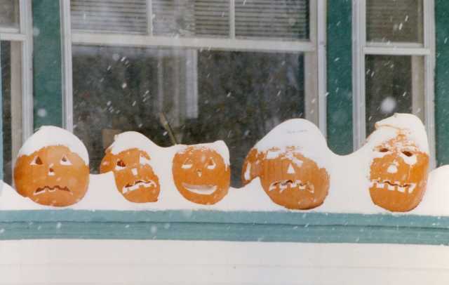
As the afternoon faded into the evening, a surreal scene unfolded with kids attempting to trick-or-treat wearing coats and boots and pumpkins becoming covered with a snowy blanket. The snow piled up steadily and without much wind initially. By the end of Halloween, 8.2 inches of snow had accumulated at the Twin Cities International Airport, the most on record for the entire month of October (October 2020 broke the record).
The storm was just beginning. In fact, it may be remembered (proudly) as the Halloween Blizzard, but the worst of the storm, including the characteristics that made it a true blizzard, held off until November 1st.
By the morning of November 1st, the low-pressure parent area had intensified and moved to southeast Iowa, with the snow reaching peak intensity in southern Minnesota and the Twin Cities between 4 AM and 9 AM, with over a foot on the ground before sunrise and a foot-and-half measured around 8 AM.
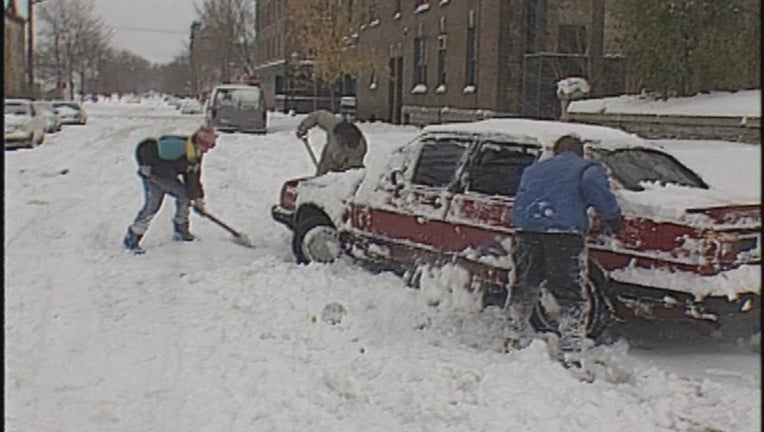
The snow led to a flurry of cancellations. 900 schools and businesses closed in Minnesota, including 3M, Dayton’s, Honeywell, and the Carlson Companies. Meanwhile, in southern Minnesota and Iowa, where the precipitation remained as rain, one to three inches of ice formed on surfaces. This was the costliest ice storm in Iowa’s history through 1991. Snow removal became difficult as the snow had started falling on warm pavement, which melted at first and then froze into icy ruts that proved to be very difficult to remove. An additional 18.5 inches fell on November 1st at the Twin Cities Airport, and snow blowers in the metro area quickly sold out.
The storm became a blizzard officially during the afternoon of November 1st. The low-pressure center headed towards Lake Superior, and intense winds gusting as high as 64 mph at Willmar spread across the state, whipping the snow into enormous drifts and dropping visibility to near zero.
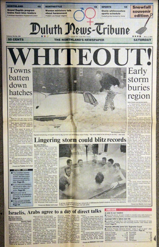
The National Weather Service issued Blizzard Warnings for much of southern, central, and eastern Minnesota (including the Twin Cities) as winds increased and additional waves of accumulating snow moved in. Even though most of the accumulating snow had ended in the Twin Cities during the late evening of November 1st, it reached extreme intensity in the Arrowhead region and Duluth during that same time, as Lake Superior, the terrain, and bouts of thundersnow combined to produce some of the highest snowfall rates of the storm.
By November 2nd, the snow was winding down, but the storm’s fierce winds ushered in a reinforcing push of cold air, forcing temperatures to fall into and through the teens across much of the state during the day. Cold air kept filtering in the proceeding days, with a low of -3 F at the Twin Cities Airport on November 4th, the earliest below-zero low on record, back to 1872.
Overall State-Wide Totals
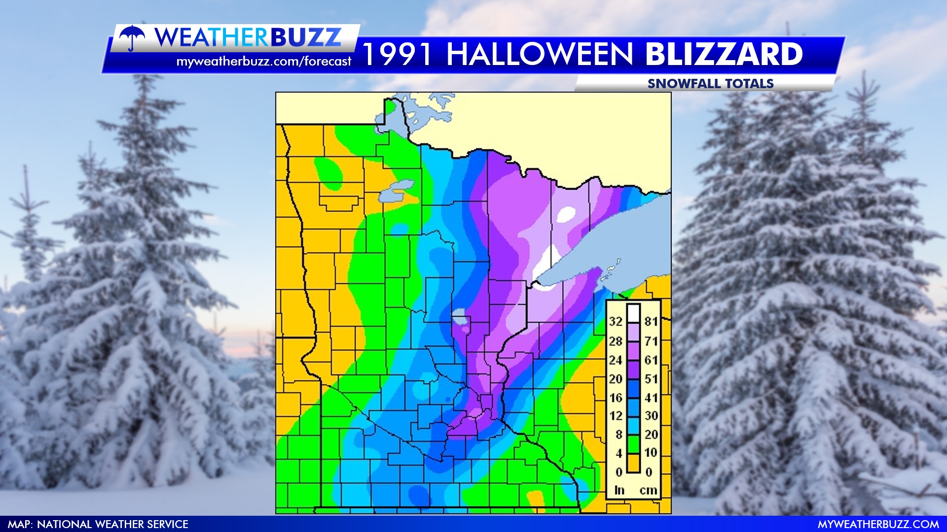
While the Blizzard of 1991 was tough around the Twin Cities and surrounding areas, trick-or-treaters in Duluth had it much worse. The snowfall started in the afternoon hours and didn’t finish until November 3rd. In that 72 hours of consecutive snowfall, Duluth received almost 37″ of snow (36.9″ officially).
Photos From the Past
As a reminder, you can always get the latest forecast on our website at any time by clicking here.
Historical Statements from the NWS in 1991
SPECIAL WEATHER STATEMENT
NATIONAL WEATHER SERVICE MINNEAPOLIS/ ST PAUL MN
945 PM CST WED OCT 30 1991
...A LOOK INTO THE CRYSTAL BALL SHOWS THAT SNOW IS IN YOUR FUTURE...
SNOW IS SPREADING INTO SOUTHWEST MINNESOTA THIS EVENING. SNOW HAS
ALREADY BEEN REPORTED IN PIPESTONE AND WORTHINGTON. VISIBILITIES WERE
REDUCED TO 1 1/4 MILE IN SIOUX FALLS JUST BEFORE 800 PM. THIS SNOW
IS EXPECTED TO SPREAD NORTHEAST INTO MINNESOTA ALONG A LINE FROM
WORTHINGTON TO THE NORTHWEST SUBURBS OF THE TWIN CITIES TONIGHT.
ACCUMULATIONS OF AN INCH OR 2 ARE POSSIBLE IN SOUTHWEST MINNESOTA NEAR
THE CITIES OF WORTHINGTON..WINDOM AND TRACY. LESSER AMOUNTS ARE
EXPECTED AS THE SNOW SPREADS EAST AND ARE NOT EXPECTED TO BE
SIGNIFICANT.
METEOROLOGISTS ARE WATCHING A GIANT STORM SYSTEM DOWN IN NEW MEXICO
THIS EVENING THAT PROMISES TO BRING SNOW INTO THE CENTRAL PLAINS DURING
THE NEXT FEW DAYS. IT IS TOO EARLY TO DETERMINE IF THE EVENTUAL
TRACK OF THIS STORM WILL BRING HEAVY SNOW TO MINNESOTA.
ALTHOUGH NO WATCHES OR WARNINGS ARE IN EFFECT FOR MINNESOTA
IT IS POSSIBLE FOR SIGNIFICANT SNOW TO BEGIN AS EARLY AS THURSDAY
EVENING IN SOUTHEAST MINNESOTA. THIS WOULD BE A OPPORTUNITY TO
DIG OUT THOSE WINTER SURVIVAL KITS FOR YOUR CARS. PLAN AHEAD NOW
FOR THE INEVITABLE SNOW THAT MINNESOTA WINTERS BRING.
SPECIAL WEATHER STATEMENT
NATIONAL WEATHER SERVICE MINNEAPOLIS/ST PAUL MN
455 PM CST FRI NOV 1 1991
...BLIZZARD WARNING MOST OF SOUTHERN MINNESOTA TONIGHT...
...WINTER STORM WARNING NORTHEAST MINNESOTA TONIGHT AND SATURDAY...
...WINTER STORM WARNING EXTREME SOUTHEAST MINNESOTA TONIGHT...
...BLOWING SNOW ADVISORY NORTHWEST MINNESOTA TONIGHT AND SATURDAY...
...BLIZZARD WARNING EXTREME WESTCENTRAL AND NORTHWEST WISCONSIN
TONIGHT WITH WINTER STORM WARNING SOUTHWEST WISCONSIN TONIGHT...
THE POWERFUL AND DANGEROUS FALL SNOWSTORM CONTINUED TO HAMMER
MINNESOTA AND WISCONSIN AT 430 PM.  SNOW WAS BEING WHIPPED BY
STRONG NORTHERLY WINDS OVER ALL OVER MINNESOTA AND NORTHWEST
WISCONSIN.  HEAVY SNOW WAS FALLING IN DULUTH MINNESOTA...WHILE
IN WEST AND SOUTHWEST WISCONSIN WHERE TEMPERATURES WERE JUST ABOVE
FREEZING...RAIN AND FOG WERE OCCURRING.  THE RAIN SHOULD CHANGE
OVER TO SNOW SOON.  DRIVING CONDITIONS WERE EXTREMELY TREACHEROUS
AROUND THE REGION AND NO TRAVEL IN OPEN RURAL AREAS IS RECOMMENDED.
IN THE TWIN CITIES...FREEWAYS AND SOME MAIN STREETS HAD BEEN PLOWED
BUT TRAVEL REMAINS DIFFICULT IN MANY AREAS.  BLOWING SNOW WAS
HAMPERING TRAVEL BY RESTRICTING VISfIBILITIES AND DUMPING SNOW BACK
IN FREEWAY ENTRANCE RAMPS AND OTHER AREAS.  TRAVEL SHOULD BE AVOIDED
UNLESS ABSOLUTELY NECESSARY.  IF YOU MUST TRAVEL...BE SURE TO HAVE
PROPER SAFETY EQUIPMENT IN YOUR CAR.  SLOW DOWN AND DRIVE WITH
EXTREME CARE.
SPECIAL WEATHER STATEMENT
NATIONAL WEATHER SERVICE MINNEAPOLIS/ST PAUL MN
540 PM CST FRI NOV 1 1991
...DANGEROUS AUTUMN SNOWSTORM BLASTS MINNESOTA AND WISCONSIN...
THE DANGEROUS FALL SNOWSTORM CONTINUED OVER MINNESOTA AND WISCONSIN
AT 530 PM.  SNOW AND BLOWING SNOW WERE OCCURRING OVER ALL OF MINNESOTA
AND WEST WISCONSIN MAKING TRAVEL EXTREMELY DIFFICULT.  FREEZING DRIZZLE
WAS OCCURRING IN WEST CENTRAL WISCONSIN.  DRIVING CONDITIONS ARE
EXTREMELY TREACHEROUS AROUND THE REGION.  NO TRAVEL IN OPEN RURAL
AREAS IS RECOMMENDED.
IN THE TWIN CITIES...FREEWAYS AND SOME MAIN STREETS HAD BEEN PLOWED
BUT TRAVEL REMAINS DIFFICULT IN MANY AREAS.  BLOWING SNOW WAS
HAMPERING TRAVEL BY RESTRICTING VISIBILITIES AND DUMPING SNOW BACK
IN FREEWAY ENTRANCE RAMPS AND OTHER AREAS.  TRAVEL SHOULD BE AVOIDED
UNLESS ABSOLUTELY NECESSARY.  IF YOU MUST TRAVEL...BE SURE TO HAVE
PROPER SAFETY EQUIPMENT IN YOUR CAR.  SLOW DOWN AND DRIVE WITH
EXTREME CARE.
Some of the Twin Cities Records that were broken by the 1991 Halloween Blizzard were:
Event	  			1991	Old Record (1891-1990)
---------------------------------------------------------------------
Most single storm snow total	28.4	21.1 (Nov 29-Dec 1 1985)
24 hour snowfall in any season	21.0	18.5 (January 23, 1982)
Most snow on October 31		 8.2	  .4 (1954)
Most snow on November 1		18.5	 3.6 (1941)
Most snow in October		 8.2	 5.5 (1905) (Broken in October 2020 with 9.3 inches)
Earliest 8 inch snow		 8.2	 8.5 (Nov 8, 1943)
Earliest autumn below zero low	  -3*	  -1 (Nov 11, 1986)
*-3 on November 4, 1991
This post provided some information by the Minnesota Department of Natural Resources and the National Weather Service.